Live Webinar – Delivering On-Demand Geoanalytics at Scale

Join us for a live webinar
Tuesday, April 18, 2017 | 10:30am EDT/3:30pm BST

Register Now

Delivering On-Demand Geoanalytics at Scale

Things have changed. Vast amounts of imagery are freely available on cloud platforms while big datasets can be hosted and accessed in enterprise environments in ways that were previously cost prohibitive. The ability to efficiently and accurately analyze this data at scale is critical to making informed decisions in a timely manner.

Developed with your imagery needs in mind, the Geospatial Services Framework (GSF) provides a scalable, highly configurable framework for deploying batch and on-demand geospatial applications like ENVI and IDL as a web service. Whether you are a geospatial professional in need of a robust software stack for end-to-end data processing, or a decision maker in need of consolidated analytics for deriving actionable information from complex large-scale data, GSF can be configured to meet your needs.

This webinar will show you real-world example applications that:

  • Describe the capabilities of GSF for scalable data processing and information delivery
  • Introduce the diverse ecosystem of geospatial analysis tools exposed by GSF
  • Illustrate the development of customized ENVI applications within the GSF environment

What are your geospatial data analysis needs?

Register Now

If you can’t attend the live webinar, register anyways and we’ll email you a link to the recording.

ENVI Analytics Symposium 2016 – Geospatial Signatures to Analytical Insights

HySpeed Computing is pleased to announce our sponsorship of the upcoming ENVI Analytics Symposium taking place in Boulder, CO from August 23-24, 2016.

EAS 2016

Building on the success of last year’s inaugural symposium, the 2016 ENVI Analytics Symposium “continues its exploration of remote sensing and big data analytics around the theme of Geospatial Signatures to Analytical Insights.

“The concept of a spectral signature in remote sensing involves measuring reflectance/emittance characteristics of an object with respect to wavelength. Extending the concept of a spectral signature to a geospatial signature opens the aperture of our imagination to include textural, spatial, contextual, and temporal characteristics that can lead to the discovery of new patterns in data. Extraction of signatures can in turn lead to new analytical insights on changes in the environment which impact decisions from national security to critical infrastructure to urban planning.

“Join your fellow thought leaders and practitioners from industry, academia, government, and non-profit organizations in Boulder for an intensive exploration of the latest advancements of analytics in remote sensing.”

Key topics to be discussed at this year’s event include Global Security and GEOINT, Big Data Analytics, Small Satellites, UAS and Sensors, and Algorithms to Insights, among many others.

There will also be a series of pre- and post-symposium workshops to gain in-depth knowledge on various geospatial analysis techniques and technologies.

For more information: http://harrisgeospatial.com/eas/Home.aspx

It’s shaping up to be a great conference. We look forward to seeing you there.

ISS National Lab Releases Gap Analysis on Earth Observation Capabilities from ISS

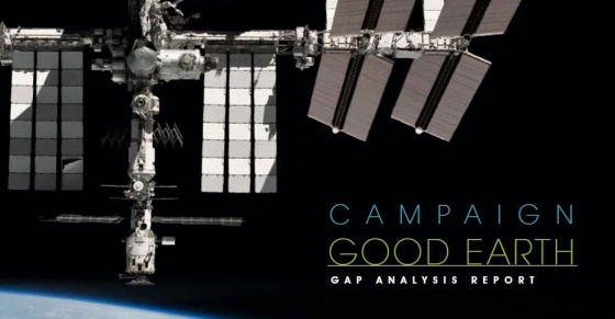
HySpeed Computing is proud to announce release of the “Campaign Good Earth, Gap Analysis Report” – authored by our own Dr. James Goodman. The report provides an investigative review of remote sensing capabilities from the International Space Station (ISS), including current facilities and resources as well as opportunities for future development.

Campaign Good Earth Gap Analysis Report

ISS National Lab, On Station (28 April 2016) – Last year, CASIS commissioned a study to evaluate the capabilities and limitations of the ISS as a host for commercial remote sensing payloads, including the products and needs of the data analytics community. A full report is now available detailing the findings of this study in the context of the expanding commercial market for Earth observation technologies and analysis.

The ISS provides a unique vantage point for Earth observation, and the ISS infrastructure itself provides many advantages as a robust platform for sensor deployment. Real-time and time-series information gathered from remote sensing applications have proven invaluable to resource management, environmental monitoring, geologic and oceanographic studies, and assistance with disaster relief efforts. This report, an analysis of the gaps between ISS capabilities and limitations in the remote sensing market, is meant to initiate a path toward optimal use of the ISS National Lab as a platform for project implementation and technology development. The report includes:

  • Expert contacts from NASA, CASIS, commercial leaders, and government agencies
  • Recommendations for how to support humanitarian and educational enrichment
  • Implementation strategies for hardware and technology adaptation on the ISS
  • Details on current and planned missions, data sources, and validation requirements

Download the report here.

Constellations, Clouds & the Conundrum of Big Data Processing

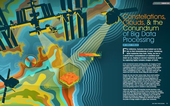
HySpeed Computing is proud to be featured in the inaugural issue of UPWARD, the quarterly magazine of the ISS National Lab.

UPWARD

Constellations, Clouds & the Conundrum of Big Data Processing

“For millennia, humans have looked up to the sky to find constellations of stars, wondering what mysteries they hold. Today, we live in a world where constellations of satellites look down on us, hoping to unravel mysteries as well – by capturing highly complex images of Earth.

“In the commercial remote sensing market, the imaging of Earth from space has experienced a technical tsunami, giving rise to a population explosion of smaller but far more capable satellites with new sensing and communication capabilities. In the near future, constellations of nano-, micro-, and other small-sats will swarm low Earth orbit like drones filling the skies on Earth.”

See the full article beginning on page 10…

Conundrum of Big Data Processing

What’s New in ENVI 5.3

As the geospatial industry continues to evolve, so too does the software. Here’s a look at what’s new in ENVI 5.3, the latest release of the popular image analysis software from Exelis VIS.

ENVI

  • New data formats and sensors. ENVI 5.3 now provides support to read and display imagery from Deimos-2, DubaiSat-2, Pleiades-HR and Spot mosaic tiles, GeoPackage vectors, Google-formatted SkySat-2, and Sentinel-2.
  • Spectral indices. In addition to the numerous indices already included in ENVI (more than 60), new options include the Normalized Difference Mud Index (NDMI) and Modified Normalized Difference Water Index (MNDWI).
  • Atmospheric correction. The Quick Atmospheric Correction (QUAC) algorithm has been updated with the latest enhancements from Spectral Sciences, Inc. to help improve algorithm accuracy.
  • Digital elevation model. Users can now download the GMTED2010 DEM (7.5 arc seconds resolution) from the Exelis VIS website for use in improving the accuracy of Image Registration using RPC Orthorectification and Auto Tie Point Generation.
  • Point clouds. If you subscribe to the ENVI Photogrammetry Module (separate license from ENVI), then the Generate Point Clouds by Dense Image Matching tool is now available for generating 3D point clouds from GeoEye-1, IKONOS, Pleiades-1A, QuickBird, Spot-6, WorldView-1,-2 and -3, and the Digital Point Positioning Data Base (DPPDB).
  • LiDAR. The ENVI LiDAR module has been merged with ENVI and can now be launched directly from within the ENVI interface.
  • Geospatial PDF. Your views, including all currently displayed imagery, layers and annotations in those views, can now be exported directly to geospatial PDF files.
  • Spatial subset. When selecting files to add to the workspace, the File Selection tool now includes options to subset files by raster, vector, region of interest or map coordinates.
  • Regrid raster. Users can now regrid raster files to custom defined grids (geographic projection, pixel size, spatial extent and/or number of rows and columns).
  • Programming. The latest ENVI release also includes dozens of new tasks, too numerous to list here, that can be utilized for developing custom user applications in ENVI and ENVI Services Engine.

To learn more about the above features and improvements, as well as many more, read the latest release notes or check out the ENVI help documentation.

ENVI 5.3

2015 ISS R&D Conference – Evolution or Revolution

The 2015 International Space Station Research & Development Conference (ISS R&D) took place recently in Boston, MA from July 7-9.

It was an amazing week of insights and information on the innovations and discoveries taking place on board the ISS, as well as glimpses of the achievements yet to come.

2015 ISS R&D

A highlight of the first day was a conversation with Elon Musk, who mused on his initial commercial forays into space, the state of his transformative company SpaceX, and a view of his vision for the future of space travel, research and exploration.

Core topics discussed at ISS R&D 2015 included everything from biology and human health, to materials development and plant science, to remote sensing and Earth observation, to space travel and human exploration. Here are a few of the top highlights:

  • NASA and its partner agencies have transitioned from assembling an amazingly complex vehicle in space to now utilizing this vehicle for the benefit of humanity.
  • The feat of building and maintaining the International Space Station is often underrated and overlooked, but it’s an incredible achievement, and everyone is encouraged to explore the marvels of what has been, and continues to be, accomplished.
  • We are advancing to a future where space transport will become commonplace, and it is the science, humanitarian, exploration and business opportunities that will be the new focus of ISS utilization.
  • The ISS is an entrepreneur engine, as evidenced in part by the rise of the new space economy. For example, new markets are emerging in the remote sensing domain, with NanoRacks, Teledyne Brown Engineering and Urthecast all making investments in expanding Earth observation from the ISS.
  • The future of the ISS, and its continued operation, is a direct function of the success or failure of what is happening on the ISS right now. The greater the success, the brighter the future.

Throughout the week a question was often asked whether the ISS is evolutionary or revolutionary… and in the end the answer was both!

Interested in learning more about the ISS? Visit the recently launched website  spacestationresearch.com to “explore the new era of science in space for life on Earth”.

Also, save the data for next year’s conference, which is taking place July 12-14, 2016 in San Diego, California. See you there!

“Space is now closer than you think.”

Innovations and Innovators in Space – Elon Musk to speak at upcoming ISS R&D Conference 2015

Join us at ISS R&D 2015 – the International Space Station Research & Development Conference taking place in Boston, MA from July 7-9 – to connect with game-changing scientists and other experts who are driving innovation through space research.

This year’s featured keynote speaker is Elon Musk – transformative entrepreneur and space visionary – who will be taking the stage on Tuesday July 7 to share “his thoughts on enabling a new era of innovators through space exploration and the International Space Station.”

Elon Musk Keynote Speaker - ISS R&D 2015

Core topics to be discussed at ISS R&D 2015 include Biology and Medicine, Human Health in Space, Commercialization and Nongovernment Utilization, Materials Development, Plant Science, Remote Sensing/Earth and Space Observation, Energy, STEM Education, and Technology Development and Demonstration.

Are you new to space research? If so, see how space can you elevate your research! There’s a New User Workshop being held on Monday July 6 before the conference begins to introduce interested users to the benefits of conducting research in microgravity and utilizing the ISS for Earth observation.

For more information on the conference: http://www.issconference.org/

We look forward to seeing you there.

Sunglint Correction in Airborne Hyperspectral Images Over Inland Waters

Announcing recent publication in Revista Brasileira de Cartographia (RBC) – the Brazilian Journal of Cartography. The full text is available open-access online: Streher et al., 2014, RBC, International Issue 66/7, 1437-1449.

Title: Sunglint Correction in Airborne Hyperspectral Images Over Inland Waters

Authors: Annia Susin Streher, Cláudio Clemente Faria Barbosa, Lênio Soares Galvão, James A. Goodman, Evlyn Marcia Leão de Moraes Novo, Thiago Sanna Freire Silva

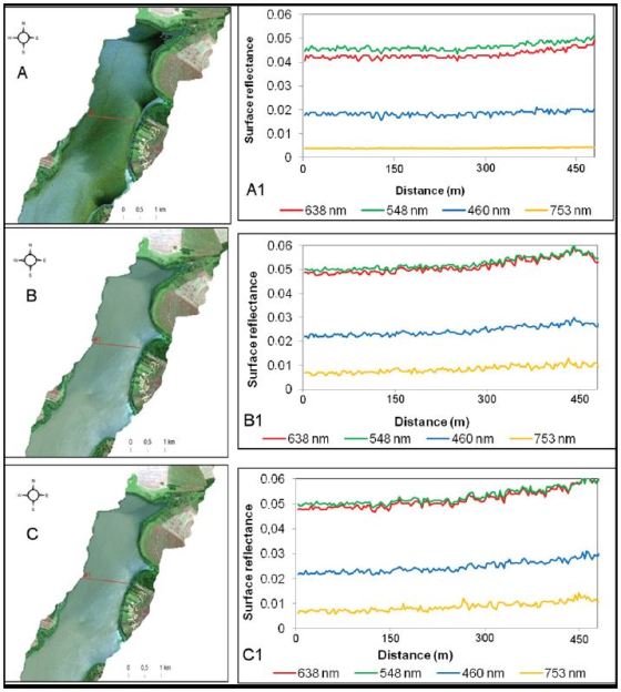
Abstract: This study assessed sunglint effects, also known as the specular reflection from the water surface, in high-spatial and high-spectral resolution, airborne images acquired by the SpecTIR sensor under different view-illumination geometries over the Brazilian Ibitinga reservoir (Case II waters). These effects were corrected using the Goodman et al. (2008) and the Kutser et al. (2009) methods, and a Kutser et al. (2009) variant based on the continuum removal technique to calculate the oxygen absorption band depth. The performance of each method for reducing sunglint effects was evaluated by a quantitative analysis of pre- and post-sunglint correction reflectance values (residual reflectance images). Furthermore, the analysis was supported by inspection of the reflectance differences along transects placed over homogeneous masses of waters and over specific portions of the scenes affected and non-affected by sunglint. Results showed that the algorithm of Goodman et al. (2008) produced better results than the other two methods, as it approached zero amplitude reflectance values between homogenous water masses affected and non-affected by sunglint. The Kutser et al. (2009) method also presented good performance, except for the most contaminated sunglint portions of the scenes. When the continuum removal technique was incorporated to the Kutser et al. (2009) method, results varied with the scene and were more sensitive to atmospheric correction artifacts and instrument signal-to noise ratio characteristics.

Keywords: coral reefs; remote sensing; field spectra; scale; ecology; biodiversity; conservation hyperspectral remote sensing, specular reflection, water optically active substances, SpecTIR sensor

Figure 5. Deglinted SpecTIR hyperspectral of Ibitinga reservoir (São Paulo, Brazil) images and resultant reflectance profiles after correction by the methods of: (a) Goodman et al. (2008); (b) Kutser et al. (2009); and (c) modified Kutser et al. (2009).

Streher et al. 2015 Fig 5 Deglint

Remote Sensing Analysis in the Cloud – Introducing the HICO Image Processing System

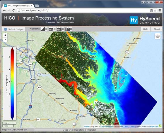
HySpeed Computing is pleased to announce release of the HICO Image Processing System – a prototype web application for on-demand remote sensing image analysis in the cloud.

HICO IPS: Chesapeake Bay Chla

What is the HICO Image Processing System?

The HICO IPS is an interactive web-application that allows users to specify image and algorithm selections, dynamically launch analysis routines in the cloud, and then see results displayed directly in the map interface.

The system capabilities are demonstrated using imagery collected by the Hyperspectral Imager for the Coastal Ocean (HICO) located on the International Space Station, and example algorithms are included for assessing coastal water quality and other nearshore environmental conditions.

What is needed to run the HICO IPS?

No specialized software is required. You just need an internet connection and a web browser to run the application (we suggest using Google Chrome).

How is this different than online map services?

This is an application-server, not a map-server, so all the results you see are dynamically generated on-demand at your request. It’s remote sensing image analysis in the cloud.

What software was used to create the HICO IPS?

The HICO IPS is a combination of commercial and open-source software; with core image processing performed using the recently released ENVI Services Engine.

What are some of the advantages of this system?

The system can be configured for any number of different remote sensing instruments and applications, thus providing an adaptable framework for rapidly implementing new algorithms and applications, as well as making these applications and their output readily available to the global user community.

Try it out today and let us know what you think: http://hyspeedgeo.com/HICO/


Related posts

Calculating a land/water mask using HICO IPS

Deriving chlorophyll concentration using HICO IPS

Evaluating water optical properties using HICO IPS

Characterizing shallow coastal environments using HICO IPS

ENVI Analytics Symposium – Come explore the next generation of geoanalytic solutions

HySpeed Computing is pleased to announce our sponsorship of the upcoming ENVI Analytics Symposium taking place in Boulder, CO from August 25-26, 2015.

ENVI Analytics Symposium

The ENVI Analytics Symposium (EAS) will bring together the leading experts in remote sensing science to discuss technology trends and the next generation of solutions for advanced analytics. These topics are important because they can be applied to a diverse range of needs in environmental and natural resource monitoring, global food production, security, urbanization, and other fields of research.

The need to identify technology trends and advanced analytic solutions is being driven by the staggering growth in high-spatial and spectral resolution earth imagery, radar, LiDAR, and full motion video data. Join your fellow thought leaders and practitioners from industry, academia, government, and non-profit organizations in Boulder, Colorado for an intensive exploration of the latest advancements of analytics in remote sensing.

Core topics to be discussed at this event include Algorithms and Analytics, Applied Research, Geospatial Big Data, and Remote Sensing Phenomenology.

For more information: http://www.exelisvis.com/eas/HOME.aspx

We look forward to seeing you there.